photo credit: Utah Geological Survey
Last August I wrote an article focused on Indiana water rights, and the lack thereof. In that article I stated “We are blessed with plenty of water in Marshall County. I assume that means the aquifers are bountiful however I haven’t been able to find specific data to support that assumption.” I’ve been on a quest since then to find out more information about Indiana aquifers.

Recent LMEF Board meetings have included discussion about the aquifer that supplies Lake Maxinkuckee and how little we know about it. LMEF is committed to being proactive in protecting Lake Maxinkuckee and it seems important to gather more information on this topic.
Aquifer
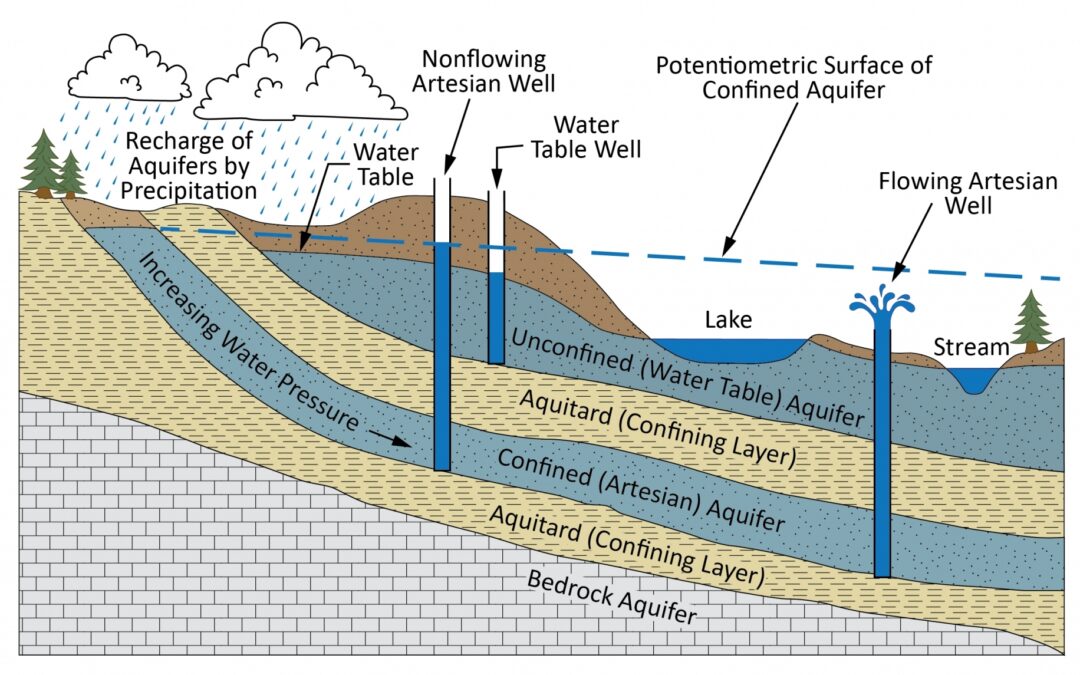
National Geographic defines an aquifer as “a body of rock and/or sediment that holds groundwater.”
Groundwater enters an aquifer as precipitation seeps through the soil. It can move through the aquifer and resurface through springs and wells. Several Lake Maxinkuckee studies have referenced the springs that feed the lake. I also wrote about local artesian wells but we actually know very little about the characteristics of our local aquifer.
Why It Matters
Groundwater can become depleted if we use it at a faster rate than it can replenish itself. Depletion of aquifers has increased primarily due to expanding agricultural irrigation however the LEAP project in Lebanon is bringing attention and scrutiny to this issue. No one really understands what the ramifications of removing such large quantities of water will be.
An article by Matt Simon in Science magazine from January 2021 reads:

“As California’s economy skyrocketed during the 20th century, its land headed in the opposite direction. A booming agricultural industry in the state’s San Joaquin Valley, combined with punishing droughts, led to the over-extraction of water from aquifers. Like huge, empty water bottles, the aquifers crumpled, a phenomenon geologists call subsidence. By 1970, the land had sunk as much as 28 feet in the valley, with less-than-ideal consequences for the humans and infrastructure above the aquifers.”
Information is Key
What I want to know:

- How fast is the groundwater in the aquifer recharging?
- How fast is it being depleted?
- What is the chemical makeup of the groundwater in the aquifer?
- What is the depth, quantity, and quality of the water?
- What impact does the aquifer have on the lake?
- Am I even asking the right questions?
I was fortunate to have a conversation with Ginger Davis, Research Geologist for the Indiana Water and Geological Survey, and share my questions with her. Davis agreed to look into our area aquifer in more detail and report her findings. Since this topic impacts the agricultural community, the local drinking water supply and the lake, I thought the public would appreciate hearing what she has to say.
LMEF has arranged for Davis to speak at Culver Academies, Bundy Auditorium in the Schrage Leadership Center, on May 1st at 7:00 pm. The public is invited, no RSVP is necessary. There will be plenty of time for questions and discussion.
Hope to see you there!


Hi, I’m Debbie Palmer. I received a BS in Horticulture from Purdue University. Here at LMEF, I am responsible for outreach presentations, monitoring the lake and it’s wetlands, project manager for restoration and research projects, and act as a community resource for all things related to the well-being of Lake Maxinkuckee and its surrounding watershed. I completed Indiana Watershed Leadership Academy, volunteer with the Indiana Clean Lakes Program, Hoosier River Watch and Marshall County Lakes and Waters and serve as a Board Member for Indiana Lakes Management Society.


Recent Comments